Top 10 Fishing Apps Every Angler Should Use
Upgrade your fishing with 2026’s top apps for tides, forecasts, maps, knots, and logs. See which tools every angler should be using.
Fishing has become increasingly data-driven, with today’s anglers relying on digital tools to understand changing conditions and make smarter decisions on the water. Weather shifts, tide movements, underwater structure, and fish behavior patterns all influence success, and mobile apps now place that information directly at your fingertips. Whether you fish from a boat, kayak, or shoreline, having accurate forecasts, detailed maps, and real-time environmental insights can help you choose the right spots and the right times to fish. Modern apps also simplify tasks such as tracking catches, scouting new areas, learning knots, and planning safe outings. As technology evolves, these tools continue to transform traditional fishing into a more informed, efficient, and accessible experience for every angler.
What Makes a Good Fishing App (What to Look For)
A reliable fishing app should deliver accurate environmental data, starting with real-time weather forecasts, tide movements, solunar activity, and wind conditions that help anglers decide the best time to fish. Mapping tools are just as important, offering GPS navigation, depth contours, satellite imagery, and the ability to save productive locations for future trips. These features help anglers understand their surroundings and adjust quickly to changing conditions, especially when applying different fishing techniques in varying environments.
Strong catch-logging tools allow users to record patterns across seasons, while offline access ensures essential information is available in remote areas. Ease of use also matters, especially for beginners who benefit from simple layouts and clear visuals. The best apps combine dependable data with practical tools, seasonal insights, and consistent updates, supporting anglers whether they fish inland, offshore, or along the coast.

Best Fishing Apps at a Glance
Modern anglers rely on digital tools to plan trips, interpret changing conditions, and stay safe on the water. These top-rated apps offer reliable data, smart features, and user-friendly tools that support better decisions and more productive outings across different fishing styles and locations.
App Name | Best For / Key Feature | Rating | Availability  |
|---|---|---|---|
1. Guidesly Pro | Best for guides managing bookings, reports, customers, and schedules | 4.5 | iOS and Android |
2. OnWater | Best for public access maps, private land boundaries, and waterway navigation | 4.4 | iOS and Android |
3. FishAngler | Best free all-in-one app with maps, logs, and forecasts | 4.5 | iOS and Android |
4. Fishing Points | Best tide, solunar, GPS, and fishing-spot tracking | 4.5 | iOS and Android |
5. Fishbrain | Best community-powered app for catches, spots, and predictions | 4.2 | iOS and Android |
6. Navionics Boating | Best marine navigation and depth charting | 4.1 | iOS and Android |
7. FishTrack Charts | Best offshore ocean-condition charts | 4.3 | iOS and Android |
8. Fishing & Hunting Solunar Time | Best solunar-based bite-time prediction | 4.4 | iOS and Android |
9. Fishing Knots | Best knot-tying tutorials and references | 4.6 | iOS and Android |
10. Fish Rules | Best fishing regulations, species size limits, and compliance guidance | 4.6 | iOS and Android |
Understanding What Each Fishing App Offers
Each fishing app delivers a different combination of tools designed to support better decisions on the water. Some focus on advanced mapping and marine navigation, while others specialize in solunar predictions, catch logging, weather insights, or essential resources like knots and regulations. These features help anglers adapt to changing conditions, refine their fishing techniques, and prepare more effectively for every outing.
Below is a closer look at all ten apps, highlighting their strengths, practical uses, and the types of anglers who benefit most.
1. Guidesly Pro
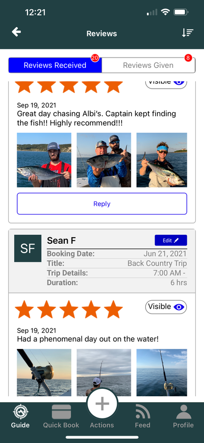
Guidesly Pro is designed for professional fishing guides who need reliable tools to manage bookings, communication, scheduling, and trip details in one place. It reduces administrative work, keeps client information organized, and supports smooth day-to-day operations, helping guides focus more on delivering successful trips and maintaining strong customer relationships.
Key Features
Booking and trip management dashboard
Client profiles with contact and trip history
Integrated scheduling and calendar tools
Trip reports and activity logging
Functionalities
Calendar syncing with upcoming trips
Automated booking and reminder notifications
Customer database management
Trip notes and post-trip documentation
Pros
Reduces administrative workload for guides
Keeps client communication organized
Improves scheduling accuracy and planning
Designed specifically for professional guides
Cons
Not designed for casual anglers
Limited use without active bookings
Fewer mapping or forecasting tools
Best value for full-time guides only
2. OnWater
OnWater is a fishing and navigation app focused on helping anglers find legal access points, understand land ownership, and navigate waterways with confidence. It is especially useful for shore, kayak, and small-boat anglers exploring unfamiliar areas.
Key Features
Public fishing access points and launch locations
Private land and property boundary overlays
Detailed waterway and shoreline maps
Offline map access for remote areas
Functionalities
GPS-based navigation and location tracking
Save favorite spots and access points
Toggle land ownership and boundary layers
Use maps without a mobile signal
Pros
Excellent for planning legal fishing access
Clear property boundaries reduce trespassing risk
Strong offline usability in remote locations
Ideal for shore and kayak anglers
Cons
Limited weather and forecast tools
No advanced catch logging features
Less useful for offshore fishing
Not an all-in-one fishing platform
3. FishAngler
FishAngler is a versatile app offering detailed maps, fishing forecasts, catch logs, and community insights for anglers of all experience levels. It provides weather conditions, species information, and real-time data that help anglers plan productive trips. Its free access to core tools makes it one of the most widely used and beginner-friendly fishing apps available today.
Key Features
Interactive fishing maps with saved locations
Catch logging with photos and notes
Fishing forecasts and bite-time insights
Species database with identification help
Functionalities
Weather and solunar tracking
Mark and revisit fishing spots
Community feed with shared catches
Trip planning tools and reminders
Pros
Free access to core features
Easy to use for beginners
Strong community-driven insights
Covers multiple fishing styles
Cons
Advanced tools require a paid upgrade
Some premium maps are locked
Community data varies by region
Notifications can feel excessive
4. Fishing Points
Fishing Points is built for anglers who rely on precise environmental data, offering tide charts, solunar forecasts, GPS tools, and detailed mapping features. It helps users plan trips around ideal conditions, save fishing spots, and navigate confidently. Its strong focus on tides and location-based insights makes it especially valuable for coastal and offshore anglers.
Key Features
Tide charts with local accuracy
Solunar forecasts for bite timing
GPS navigation and location tools
Fishing spot saving and tracking
Functionalities
Offline map access
Waypoint marking and navigation
Weather condition updates
Trip logging and planning tools
Pros
Highly accurate tide data
Reliable solunar predictions
Strong mapping and GPS tools
Useful for coastal anglers
Cons
Offline features may require a subscription
Limited community interaction
Interface can feel data-heavy
Less focus on freshwater fishing
5. Fishbrain
Fishbrain combines fishing data with social insights, giving anglers access to shared catch reports, local hotspots, and predictive tools. It supports trip planning with species information, weather details, and gear recommendations. Its community-driven approach helps anglers discover new locations and learn from others while tracking their own fishing activity.
Key Features
Community-shared catch reports
Hotspot and activity maps
Species insights and identification
Fishing predictions and trends
Functionalities
Catch logging with photos
Weather-based forecasting tools
Gear and bait recommendations
Spot marking and location saving
Pros
Very strong angler community
Large database of catch data
Helpful location-based insights
Good discovery tool for new spots
Cons
Many advanced maps require paid access
Popular spots can become crowded
Predictions vary by region
Notifications can feel overwhelming
6. Navionics Boating
Navionics Boating is a leading app for marine navigation, offering detailed charts, depth contours, and route-planning tools trusted by boaters and offshore anglers. It provides accurate maps, sonar features, and real-time updates that support safe navigation and effective scouting in coastal and deep-water environments.
Key Features
Detailed nautical and marine charts
Depth contours and bathymetric mapping
Sonar and chart overlay tools
Advanced route planning features
Functionalities
GPS tracking and live positioning
Auto-routing for safe navigation
Regular chart and data updates
Offline map and chart access
Pros
Highly accurate and reliable charts
Ideal for offshore and boating anglers
Professional-grade navigation tools
Strong support for marine safety
Cons
Subscription required for advanced layers
Less useful for shore anglers
The interface may feel complex for beginners
Limited fishing-specific insights
7. FishTrack Charts
FishTrack Charts provides offshore anglers with access to vital ocean data, including sea-surface temperatures, chlorophyll levels, currents, and marine charts. These insights help identify productive offshore zones and plan safer, more informed trips. It is especially useful for anglers targeting pelagic species in deep or open waters.
Key Features
Sea-surface temperature charts
Chlorophyll and productivity maps
Offshore marine forecasts
Advanced ocean mapping tools
Functionalities
Route planning for offshore trips
Waypoint marking and saving
Weather and current overlays
Ocean condition tracking
Pros
Excellent offshore scouting capability
High-quality environmental data
Useful for targeting pelagic species
Supports informed safety decisions
Cons
Best suited for deep-sea anglers
Limited value for freshwater fishing
It can feel complex for beginners
Requires experience to use effectively
8. Fishing & Hunting Solunar Time
Fishing & Hunting Solunar Time helps anglers predict peak activity windows using solunar theory, offering daily ratings, major and minor feeding times, moon phases, and sunrise–sunset data. It is especially helpful for anglers who plan trips around behavior patterns influenced by lunar and solar cycles.
Key Features
Solunar forecasts based on moon and sun positions
Clearly defined major and minor feeding periods
Moon phase tracking with daily visibility details
Overall day ratings for fishing activity
Functionalities
Location-based solunar predictions
Sunrise and sunset time tracking
Basic weather condition reference
Activity timing tools for trip planning
Pros
Very easy for beginners to use
Reliable bite-time predictions
Clean and distraction-free interface
Useful for quick timing decisions
Cons
Limited mapping and navigation tools
No catch logging or history tracking
Not designed for detailed trip planning
Works best when paired with other apps
9. Fishing Knots
Fishing Knots provides step-by-step instructions for tying a wide range of knots used in various fishing situations. With clear visuals and categorized tutorials, the app helps anglers learn and practice knots suited for different lines, hooks, and techniques. It is especially valuable for beginners and anyone refining essential skills.
Key Features
Wide range of fishing knot tutorials
Clear visual guides and illustrations
Category-based knot organization
Knots matched to fishing techniques
Functionalities
Step-by-step knot animations
Offline access to tutorials
Line and knot-type recommendations
Quick reference search tools
Pros
Very easy to follow and understand
Ideal for beginners and learning anglers
Useful on-the-water reference
No unnecessary distractions
Cons
Limited to knot-related content only
No fishing forecasts or maps
Lacks trip planning tools
Best used alongside other apps
10. Fish Rules
Fish Rules helps anglers understand and follow fishing regulations by providing clear, location-based rules for species limits, seasons, measurements, and gear requirements. The app automatically adjusts regulations based on GPS or manually selected areas, ensuring users stay compliant on both saltwater and freshwater trips. Its visual guides and easy rule breakdowns make it especially useful for preventing accidental violations and supporting responsible, informed angling.
Key Features
Location-based fishing regulations
Species size and bag limits
Open and closed season details
Gear and method restrictions
Functionalities
GPS-based regulation updates
Manual region and water selection
Photo-based species identification
Visual rule breakdowns
Pros
Very accurate regulatory information
Easy-to-read and visual limits
Reduces risk of accidental violations
Useful for both freshwater and saltwater
Cons
Coverage varies by region
Works best in supported locations
Limited planning or mapping tools
Requires location access for accuracy
How to Choose The Right App for You

Choosing the best fishing app for my needs becomes easier when you break the decision into a few simple steps. This section explains how to define your fishing style, identify the features you rely on most, understand recommended app combinations for different anglers, and evaluate the key trade-offs that determine which app is the right fit.
Identify Your Fishing Style
Here are the key factors that shape your fishing approach, helping you understand which features matter most and which apps will genuinely support your decisions on the water.
Freshwater vs. Saltwater: Freshwater anglers often need lake maps, structure detail, and spot markers, while saltwater anglers depend heavily on tides, currents, marine navigation, and wind patterns.
Boat vs. Shore Fishing: Boat anglers benefit from GPS routing, bathymetry, and offshore planning tools. Shore anglers rely more on access points, accurate shoreline depth, and structure scouting.
Casual vs. Serious Anglers: Casual anglers may want basic forecasts and simple tools. Serious anglers often require solunar data, long-term logs, and high-detail maps.
Occasional vs. Frequent Fishing: Occasional anglers prefer lightweight, easy apps, while frequent anglers gain more from long-term data storage and multi-feature dashboards.
Clarify What You Need Most
After defining your style, the next step is identifying which functions will improve your fishing decisions. Anglers look for different kinds of information, and recognizing these priorities helps narrow down the best fishing app for my needs.
Forecasts and tide information: Useful for timing trips and understanding daily conditions.
Detailed maps and navigation: Ideal for scouting new areas, reading structure, and planning routes.
Long-term catch logging: Helps track patterns and refine techniques across seasons.
Tackle and gear logging: Supports anglers who manage multiple rigs, baits, and species.
All-in-one platforms: Best for anglers who want mapping, forecasting, logs, and planning in one place.
Starter Recommendations
Different anglers benefit from different app combinations. Here are practical app combinations tailored to different fishing styles and experience levels, helping you build a setup that delivers the essential tools you need for effective planning and better on-water decisions.
Angler Type | Suggested App Setup |
|---|---|
Beginners | One map or spot-finding app + a tide or forecast app + a simple catch log |
Experienced Anglers | A hybrid or all-in-one platform combining maps, logs, and forecasts |
Saltwater Anglers | Tide/current forecasts + marine charts + wind and ocean condition layers |
Freshwater Anglers | Structure maps + catch logs + species-based tools for refinement |
Boat Anglers | GPS routing + bathymetry + offline charts + reliable weather tools |
Key Trade-Offs to Consider
Every fishing app comes with strengths and limitations. Understanding these trade-offs helps you select options that align with your habits, privacy preferences, and device limitations. Here are important factors that influence how well a fishing app fits your needs:
Feature richness vs. simplicity: Advanced tools offer depth but can slow decision-making for beginners.
Social features vs. privacy: Community insights are helpful, but some anglers prefer to keep locations private.
Free vs. subscription access: Free versions cover basics; paid tiers offer enhanced maps and offline layers.
Battery and data usage: GPS, maps, and forecasts can drain battery life quickly.
Offline support: Essential for remote lakes, offshore zones, and backcountry locations with weak signal.
How These Apps Complement Fishing Techniques & Strategies
Fishing apps enhance a wide range of fishing techniques by helping anglers understand timing, structure, and environmental shifts that influence fish behavior. Accurate forecasts, tide charts, and solunar data support techniques like spin fishing, bottom fishing, and heavy-tackle fishing by showing when conditions align with peak feeding windows. Mapping tools and bathymetry improve strategic decisions in both freshwater and saltwater settings, especially when targeting offshore or migratory species. Pairing these digital insights with species information deepens understanding of how fish respond to seasonal patterns, water changes, and location-specific variables. Together, these tools strengthen technique execution, refine decision-making, and help anglers plan more productive outings.
Caveats & Best Practices: Don’t Rely on Apps Alone
Here are important considerations to keep in mind when using fishing apps, helping you understand their limits, protect your data, and maintain strong on-water awareness while relying on technology as a support tool rather than a replacement for skill.
Data accuracy varies by location: Forecasts, tide charts, and bathymetric layers can be incomplete or outdated in remote areas, leading to gaps in information.
Conditions change faster than apps update: Weather shifts, tide swings, and sudden wind changes can occur more quickly than real-time tools can refresh.
Skill still matters: Understanding fish behavior, reading structure, choosing the right gear, and applying proper techniques remain essential regardless of the app you use.
Privacy and data ownership: Some catch-logging apps share information publicly unless settings are adjusted. Review privacy options and decide what to keep private.
Avoid unnecessary distractions: Social feeds inside certain apps can pull attention away from actual fishing and slow reaction time on the water.
Backup access is essential: Offline charts, downloaded maps, and fully charged devices prevent disruptions when the signal is weak or unavailable.
Conclusion
Fishing apps can improve planning, highlight productive windows, and simplify decisions, but the best results come from choosing tools that match your fishing style, target species, and experience level. Start with one or two reliable apps, then expand your toolkit as you learn what information truly supports your time on the water. Combining digital insights with strong fundamentals creates a balanced, informed approach to every trip. For more help choosing locations, understanding species behavior, and refining your techniques, explore Guidesly’s resources, articles, and expert guidance. Visit Guidesly to continue improving your fishing experience with tools designed for anglers.
FAQs
1. What type of fishing app is most helpful for beginners?
Beginner anglers benefit most from simple apps offering clear visuals, easy navigation, and basic trip tools that help build confidence without overwhelming features.
2. Do fishing apps work without an internet connection?
Some apps support offline access, but performance depends on whether users download maps or charts beforehand, ensuring essential information remains available even with weak connectivity.
3. How often should anglers update their fishing apps?
Regular updates ensure access to fresh data, improved features, and bug fixes, helping anglers rely on current tools rather than outdated or inaccurate information while planning.
4. Are fishing apps useful for planning multi-day trips?
Yes, many apps help monitor extended weather patterns, organize saved spots, and maintain trip notes, offering structure and continuity across several consecutive fishing days.
5. Can fishing apps help identify unfamiliar locations safely?
Some apps highlight hazards, navigation routes, or restricted areas, giving anglers additional context when exploring new waters where visibility or local knowledge may be limited.
6. Do fishing apps provide value during winter months?
Winter fishing apps track temperature changes, light periods, and ice conditions, helping anglers adjust strategies safely despite challenging seasonal variations and reduced predictability.
7. Should anglers use one fishing app or multiple apps?
Using multiple apps offers broader coverage, allowing anglers to compare data, confirm patterns, and incorporate features unavailable in a single platform, supporting more informed planning.
8. Are fishing apps suitable for family or group trips?
Many apps support shared planning, allowing groups to coordinate meeting spots, compare conditions, and maintain communication, making collaborative outings more organized and enjoyable.
9. How do fishing apps support conservation practices?
Some apps highlight catch limits, protected zones, and local guidelines, encouraging anglers to follow sustainable habits and respect regulations to protect fisheries long-term.
10. Do fishing apps help track gear performance over time?
Certain apps let anglers log equipment details, helping identify which gear combinations work best under specific conditions, supporting better purchasing decisions and fishing preparedness.